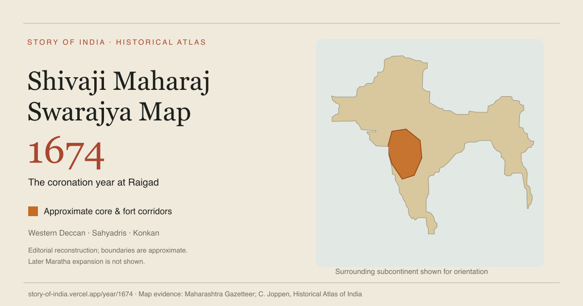
Explore Shivaji Maharaj’s Swarajya on the map of India in 1674, the year of his Raigad coronation. Boundaries show the approximate western Deccan core and fort corridors.
A living atlas of the subcontinent 3300 BCE — 2026 CE
Today’s time machine
Map guide · Shivaji Maharaj’s kingdom
Swarajya map during Shivaji Maharaj’s coronation
Explore the Swarajya of Chhatrapati Shivaji Maharaj in 1674, the year of his coronation at Raigad. This map places the kingdom’s western Deccan core and fort corridors within the Indian subcontinent, with the Konkan coast and Sahyadri hills as geographic context. Swarajya means self-rule; here it describes the kingdom associated with Shivaji Maharaj, in its seventeenth-century setting.
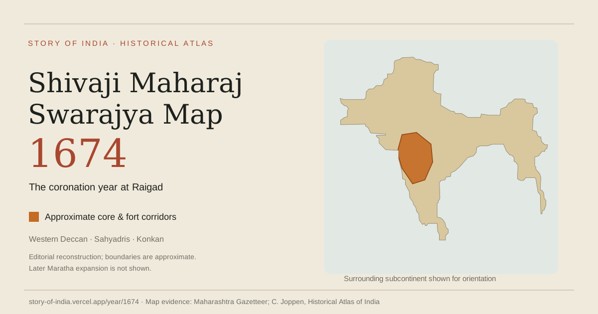
Shivaji Maharaj’s Swarajya in 1674. Orange marks the atlas’s approximate core and fort corridors. The surrounding land provides geographic context; this is an editorial reconstruction, not a surveyed boundary or a map of the later Maratha Empire.
Where was Shivaji Maharaj’s Swarajya on the map of India?
Start with western India: the Sahyadri range, also called the Western Ghats, the Konkan coast to its west, and routes into the Deccan plateau. These landscapes help explain why hill strongholds, mountain passes and coastal defences mattered together. The orange footprint is a simplified reading of the kingdom’s core and fort corridors, rather than a claim that every place inside it had identical administration.
Present-day Maharashtra helps locate this history, but its state boundary is not the boundary of Swarajya. Nor does a map of Shivaji Maharaj’s India mean that he ruled the whole subcontinent. Political control, military access and contested frontiers need to be read separately. Source: UNESCO’s military landscape description.
Raigad, hill forts and the Konkan coast
Raigad is the key place to connect to the date 1674: Shivaji Maharaj was crowned Chhatrapati there on 6 June. The fort served as a capital and a centre of government. Source: Press Information Bureau’s Raigad history.
To understand the wider military geography, read hill forts such as Rajgad and Pratapgad alongside coastal strongholds such as Sindhudurg. UNESCO treats Maratha fortifications as a connected defence system that used terrain to support territorial control and protect trade. Its heritage listing covers several reigns and centuries, so the twelve listed forts should not be treated as a ready-made inventory of territory held in 1674. Source: UNESCO.
How to read this historical map
Begin with the orange Swarajya footprint in western India. Hover or select it in the interactive atlas to read its label and related history.
Use the map legend and linked evidence to distinguish approximate political geography from a precise modern border.
Use the timeline or Compare control to explore another date. Return to 1674 for the coronation-era snapshot.
The downloadable image uses the same territory geometry as the interactive 1674 snapshot. Its footprint is approximate; the gazetteer and historical atlas references below document the reconstruction’s evidence. Individual fort locations are not plotted on this overview.
Is this the same as a Maratha Samrajya map?
A Shivaji Maharaj Samrajya map may refer to his kingdom, while a Maratha Empire map can depict a much later political world. This page fixes the date at 1674. UNESCO describes a military tradition that developed under Shivaji Maharaj and continued under his successors until 1818. That longer history should not be compressed into the founder’s coronation year. Source: UNESCO.
६ जून १६७४ को रायगढ़ में शिवाजी महाराज का राज्याभिषेक हुआ। इस मानचित्र में नारंगी रंग उनके स्वराज्य के मुख्य क्षेत्र और किलों से जुड़े मार्गों का अनुमानित विस्तार दिखाता है। सह्याद्रि की पहाड़ियाँ, कोंकण तट और दक्कन का भूगोल इस इतिहास को समझने में मदद करते हैं।
आज के महाराष्ट्र की सीमा को १६७४ के स्वराज्य की सीमा नहीं मानना चाहिए। यह मानचित्र बाद के मराठा साम्राज्य का पूरा विस्तार भी नहीं दिखाता। 1674 को हिंदी अंकों में १६७४ और शब्दों में “सोलह सौ चौहत्तर” लिखा जाता है। राज्याभिषेक का स्रोत · किलों और भूगोल का स्रोत।
Sources for the Swarajya map and history
Original guide by the throughTimes Editorial Team. Institutional sources support the historical context; the gazetteer and historical atlas are references for the approximate map reconstruction.
Deccan Sultanates (Ahmadnagar, Bijapur, Golconda, Berar, Bidar) Deccan plateau. Successor states of the Bahmanis; the last, Golconda, fell to Aurangzeb in 1687.Source: Encyclopaedia Britannica — Adil Shahi dynasty
Kingdom of Mysore Southern Karnataka. Wodeyar kingdom, independent of Vijayanagara from about 1610; under Hyder Ali and Tipu Sultan from 1761 to 1799.Source: Encyclopaedia Britannica — Wadiyars
Mewar (Sisodia Rajputs) Southern Rajasthan; capitals Chittor, later Udaipur. Rajput kingdom of Rana Kumbha, Rana Sanga and Maharana Pratap; a princely state under British paramountcy from 1818, merged into Rajasthan in 1949.Source: Encyclopaedia Britannica — Udaipur (historical state)
Portuguese India (Goa, Daman and Diu) Goa and coastal enclaves. Goa was taken in 1510 and remained Portuguese until 1961.Source: Encyclopaedia Britannica — Goa
What happened in India around 1674 CE?
1665–1666: Purandar and Agra expose the pressures around Swarajya. The Treaty of Purandar required Shivaji Maharaj to surrender forts and accept difficult terms after Jai Singh’s campaign. His later detention and escape from Agra reopened the contest rather than ending it. Source: Maharashtra Gazetteers: History of Maharashtra
1666 CE: Shivaji Maharaj escapes confinement at Agra
1668: The Company leases Bombay. The English Crown leased Bombay to the East India Company, giving a trading corporation an enduring coastal base. Source: Mumbai City District — History
6 June 1674: The coronation at Raigad asserts sovereignty. Shivaji Maharaj’s coronation at Raigad publicly established him as Chhatrapati and gave the kingdom a formal sovereign centre. A second ceremony later that year reflected the importance attached to ritual legitimacy as well as political power. Source: Maharashtra Gazetteers — History of Maharashtra
1680–1818: Maratha power grows beyond its founder. After Shivaji Maharaj’s death, the state survived severe Mughal pressure and later expanded under the Chhatrapatis, Peshwas and several powerful Maratha houses. This wider confederated order was influential across much of the subcontinent but was not a single uniformly centralized administration. Source: Encyclopaedia Britannica — Maratha confederacy
1687: Golconda falls to Mughal forces. Aurangzeb’s forces captured the nearby Qutb Shahi stronghold of Golconda. This is a regional political transition, not a surveyed boundary of Hyderabad city. Source: Hyderabad District — Golconda Fort
1690: Charnock arrives at Sutanuti. The municipal history records Job Charnock’s arrival at Sutanuti. This date concerns the Company’s presence amid existing settlements, rather than the beginning of all urban life here. Source: Kolkata Municipal Corporation — Municipal History
Major Historical Milestones in 1674 CE
1674 CE: Shivaji Maharaj is crowned at Raigad
Historical Events & Sourced Records (1674 CE)
Shivaji Maharaj turns Swarajya into a durable state
Born at Shivneri, Shivaji Maharaj steadily built an independent kingdom from a contested Deccan landscape. He combined military initiative with negotiation, revenue administration and the careful appointment of officers rather than relying on battlefield success alone.
The Marathi term Swarajya expressed self-rule. Its seventeenth-century political meaning should be understood in its own setting, not treated as identical to the later democratic nation-state.
Shivaji Maharaj’s coronation at Raigad publicly established him as Chhatrapati and gave the kingdom a formal sovereign centre. A second ceremony later that year reflected the importance attached to ritual legitimacy as well as political power.